
For STEM educators, DIY flyers & teams flying to the edge of space
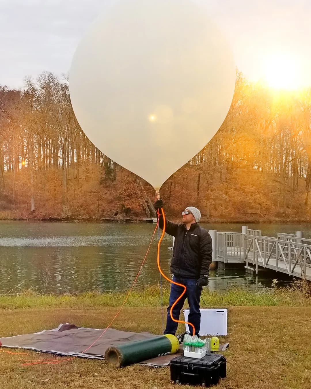
How to Launch a Weather Balloon
& Get It Back
Whether it's a class project on a $400 budget or your hundredth flight, the hard part was never the launch — it's predicting where it lands, tracking it the whole way, and recovering it. We've done it 100+ times. Here's how it works, and the free tools that make it predictable.
The 30-Second Version
- ▸A weather balloon carries a small payload to the edge of space — typically 70,000–90,000 ft (sometimes past 120,000), above 99% of the atmosphere.
- ▸It rises about 1,000 ft/min for roughly 90 minutes, growing from ~6 ft to ~27 ft across before it bursts.
- ▸A parachute (already deployed under the balloon) brings it down — fast in thin air, slowing to ~10 mph near the ground.
- ▸The three things that actually go wrong: predicting the landing, tracking it live, and recovering it.
- ▸You can predict a flight to within about a 10-mile radius — most accurate within 12 hours of launch.
- ▸Realistic DIY cost: about $400 in consumables per launch, 2–3 launches a year.
Who it's for
Teachers, clubs, DIY flyers, hobbyist engineers
Budget
~$400 / launch in consumables
Difficulty
Beginner-friendly with the right tools
Time
~10 class periods; launch day ~4 hrs
The Guide: How a Flight Actually Works
How high does a weather balloon go?
Most reach 70,000–90,000 ft before bursting — and can range from 60,000 to over 120,000 ft depending on balloon size, gas fill, and payload weight. That is above 99% of the atmosphere, into temperatures below −50°F and radiation similar to the ISS.
How high can a balloon go before it pops?How far will it travel?
It depends on the jet stream. Warm months: 2–35 miles. Cold months: 35–90+ miles — we have clocked the jet stream over 200 mph in January over the Midwest.
How long will it stay in the air?What can you fly on it?
Anything that fits your weight budget — cameras, sensors, student experiments. Your total payload weight sets the balloon and parachute size you need.
How much weight can it carry?Who do you need on the team?
Like a NASA mission, the best flights split the work: a Mission Director, a Launch Site Director, a Recovery Director, and someone on photos and updates. One person can do it, but a small team makes it far easier — and safer.
What You Need (Bring Your Own)
- •Latex weather balloon
- •Lift gas — we recommend helium
- •Parachute
- •A tracker that works at altitude
- •Payload enclosure
- •Camera + large SD card
- •Hiking GPS for recovery
Helium vs. hydrogen — go with helium
Hydrogen is cheaper and lifts more, but it's flammable and brings real safety and valving and handling issues that aren't worth it for a classroom or DIY flight. Helium is inert, far safer to fill and handle, and the right default for almost everyone.
The Three Things That Make or Break a Flight
We've launched over 100 balloons. The launch itself is the easy part — these three are where flights are won or lost, and they're exactly what our software and flight models are built to solve.
Predicting the flight
A few miles of error means a payload in a lake instead of a field. Prediction is a model problem — and it only gets better with real flight data.
Seeing it live
Raw tracker pings aren't a flight. Turning whatever tracker you fly into a live map and telemetry is the difference between watching a mission and refreshing a spreadsheet.
Getting it back
Recovery is logistics: terrain, access, timing, and a landing prediction you can trust. Most GPS units quit above 60,000 ft, and cell phones are dead in recovery zones — plan for a hiking GPS.
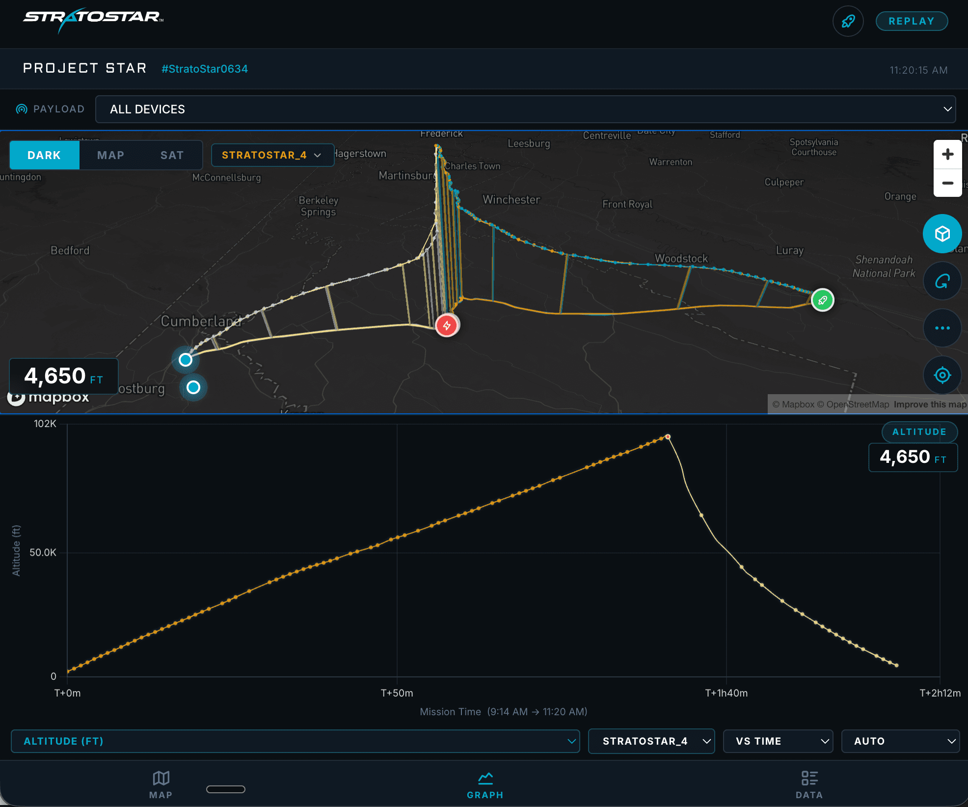
See a Real Flight: Forecast vs. What Actually Happened
This is a real StratoStar mission (Project STAR, Virginia, May 2025) in Mission Control — the live 3D map and full telemetry, launch to recovery. And here's the honest part most sites won't show you: how the forecast compared to reality.
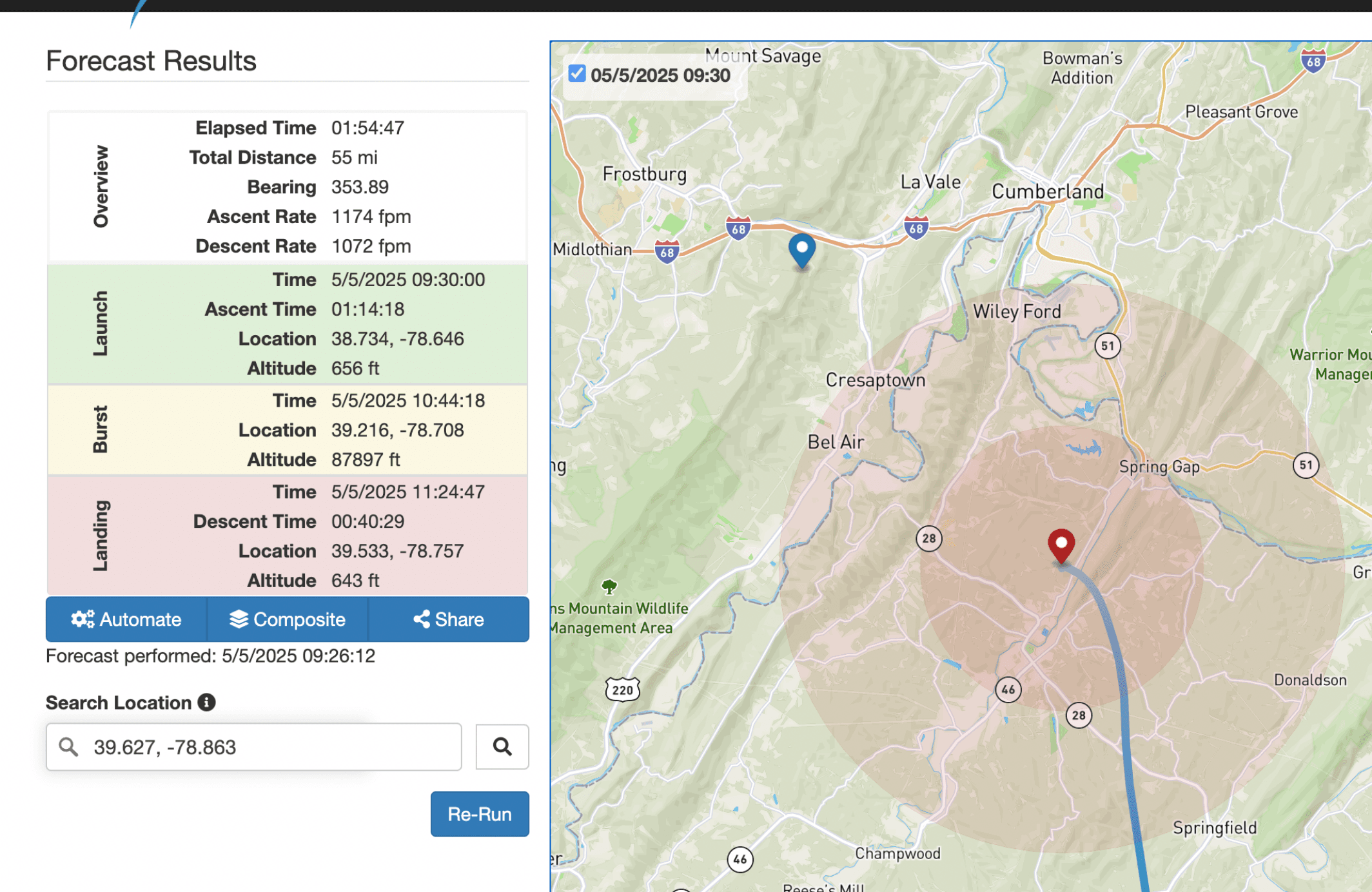
| We forecast | It actually did | |
|---|---|---|
| Burst altitude | 87,897 ft | 97,061 ft |
| Landing | 39.533, -78.757 | 39.627, -78.863 |
| Direction | 354° (due north) | ~351° (due north) |
The balloon burst about 9,000 ft higher than forecast — so it flew roughly 9 miles farther than predicted, and landed about 8.6 miles from the forecast point: still inside the ~10-mile accuracy window we tell every flyer to plan for. Direction was nearly dead-on; the variable was burst altitude — exactly the kind of thing the model gets sharper at with every real flight it sees.
Flown with multiple trackers — and it mattered
On this flight, one tracker lost signal at 4,650 ft, still descending. A second tracked the balloon all the way to a remote 2,000-ft ridge. The tracker that keeps transmitting is the one that gets you to your payload — which is why our software is built to take data from whatever you fly.
Prefer to Watch? Launch Day, Step by Step
How to prepare a weather balloon for launch
How to fill a weather balloon
How to launch a weather balloon
Predict It. Fly It. We'll Grade It.
We're building software that turns flight data from any tracker into a live mission page — and gets sharper at predicting flights with every real flight it sees. Here's the idea. The free layer is public; you pay in data, not dollars.
- 1
Run a prediction
Free, today — see your burst altitude and landing zone.
- 2
Fly your balloon
With whatever tracker you already have.
- 3
Send us your data + notes
What went right, what went wrong.
- 4
We host and verify it
A public mission page — forecast vs. what actually happened.
- 5
Go live (coming)
Upgrade to a live-tracking dashboard for your next flight.
Real example:on our May 2025 Virginia flight we forecast an 87,897 ft burst; it actually hit 97,061 ft and flew ~9 miles farther — still landing inside the 10-mile window. Send us a flight and we'll show you yours, forecast vs. actual.
Have Flight Data? We'll Host It.
Run a prediction free today. Want us to host your flight and grade your forecast against what really happened? Get early access — tell us where you're at below and we'll be in touch. No commitment.
What to bring
A CSV, Excel, or Google Sheet with one row per reading. Include the units for any column (we'll confirm them with you).
Required: latitude, longitude
Strongly wanted: altitude (m/ft), timestamp
Nice to have: temperature, pressure, battery voltage
Nice to have: speed, heading, vertical rate
Works With Your Tracker
Bring whatever you fly — we turn the pings into a live mission. Here's what works for weather balloons, and what doesn't.
| Tracker | Works? | Notes |
|---|---|---|
| Satellite radio (SPOT Trace / Globalstar) | Best | Easiest; keep it clear of other electronics |
| HAM radio (line-of-sight) | Works | Reliable, but needs a license + a ground or chase receiver |
| LoRa (line-of-sight) | Works | Public radio frequency; needs a ground receiver |
| LoRaWAN (line-of-sight hybrid) | Partial | Public ground-station network; can miss the final landing spot |
| Cellphone | No | Illegal on aircraft (FCC) and no rural coverage |
| GSM / SIM (pet & vehicle trackers) | No | Illegal under FCC rules; no landing coordinates |
| Apple AirTag (Bluetooth) | No | Only works in dense areas; balloons land rural |
Common Questions
Yes. The physics aren't exotic — a latex balloon, lift gas, a parachute, a tracker, and a payload. What's hard is doing it reliably: predicting the flight, tracking it live, and recovering it. Those are the parts good tools and experience make far easier.
Typically 70,000–90,000 ft, and it can range from 60,000 to over 120,000 ft — above 99% of the atmosphere. Exact burst altitude depends on the balloon, gas fill, and payload weight, which is why flight prediction matters.
That's the point of where we're headed — software that ingests data from whatever tracker you already fly (SPOT, HAM, LoRa, LoRaWAN, and more) and turns it into a live mission view, instead of locking you to one brand of radio.
Hobby high-altitude balloons in the US fall under the FAA's unmanned free balloon rules (14 CFR Part 101). Before you launch, you file a NOTAM (Notice to Air Missions) so nearby aircraft are alerted to your flight. Light payloads are largely exempt from Part 101's operating limits, but you're still responsible for flying safely — and heavier payloads trigger additional notification and operating requirements. Check current FAA guidance before you fly.
Plenty of teams start out planning a DIY launch and realize it's a real time commitment to do safely and repeatably. If that's you, StratoStar also flies payloads as a service — you get the data and your hardware back without running the operation yourself.
Written by Jason Krueger, founder of StratoStar — 100+ near-space launches. Figures are drawn from StratoStar flight logs.